![](/images/other/stat-length.png)
![Trail Walking La Cadière-d'Azur - La Cadière d'Azur-05-11-21 - Photo](https://media.geolcdn.com/t/1900/400/a288581b-7355-480f-a49b-5032cbc56a63.jpg&format=pjpeg&maxdim=2)
La Cadière d'Azur-05-11-21
Christiancordin
User
![Length](/images/other/stat-length.png)
Length
7.9 km
![Max alt](https://static1.geolcdn.com/siteimages/upload/files/1508320355ic_sort_altitude_max_24dp.png)
Max alt
226 m
![Uphill gradient](https://static1.geolcdn.com/siteimages/upload/files/1508320355ic_sort_den_pos_24dp.png)
Uphill gradient
189 m
![Km-Effort](/images/other/stat-length.png)
Km-Effort
10.4 km
![Min alt](https://static1.geolcdn.com/siteimages/upload/files/1508320355ic_sort_altitude_min_24dp.png)
Min alt
101 m
![Downhill gradient](https://static1.geolcdn.com/siteimages/upload/files/1508320355ic_sort_den_neg_24dp.png)
Downhill gradient
186 m
![Boucle](https://static1.geolcdn.com/siteimages/upload/files/16400158638029165_repeat_loop_refresh_sync_direction_icon.png)
Boucle
Yes
Creation date :
2021-11-05 10:13:52.12
Updated on :
2021-11-05 18:08:50.971
![Walking](https://static1.geolcdn.com/sitytour/trail-icons/101.png)
2h48
Difficulty : Easy
![Scan this QR Code to open this trail in the SityTrail application](https://capi.geolives.com/qq0zvz2zws4bq2lad0pu/sitytour/trails/2993203/qr.png?size=200)
FREE GPS app for hiking
About
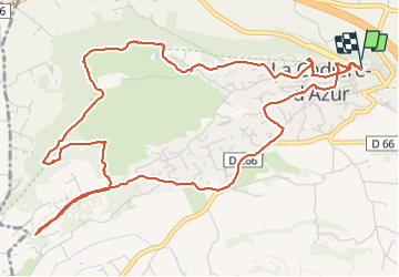
Trail Walking of 7.9 km to be discovered at Provence-Alpes-Côte d'Azur, Var, La Cadière-d'Azur. This trail is proposed by Christiancordin.
Description
Pk en bas du village-table d'orientation-Chapelle Ste Croix-panorama Ste Baume et baie de la Ciotat-monument de la paix.
Positioning
Country:
France
Region :
Provence-Alpes-Côte d'Azur
Department/Province :
Var
Municipality :
La Cadière-d'Azur
Location:
Unknown
Start:(Dec)
Start:(UTM)
724086 ; 4786364 (31T) N.
Comments
Trails nearby
![Trail Walking Le Beausset - Trace_Quatre_Freres - Photo](https://media.geolcdn.com/t/375/260/a076bf67-1e95-4bda-8264-007e64206af1.jpg&format=jpg&maxdim=2)
![Walking Walking](https://static1.geolcdn.com/sitytour/trail-icons/101.png)
Trace_Quatre_Freres
Walking
Very difficult
(1)
Le Beausset,
Provence-Alpes-Côte d'Azur,
Var,
France
![](/images/other/stat-length.png)
14.8 km | 19.6 km-effort
4h 26min
![](https://static1.geolcdn.com/siteimages/upload/files/16400158638029165_repeat_loop_refresh_sync_direction_icon.png)
Yes
![Trail Walking Le Beausset - Tête du Cade par abime de Maramouyé - Photo](https://media.geolcdn.com/t/375/260/ext.jpg?maxdim=2&url=https%3A%2F%2Fservices.sitytrail.com%2FGeolivesWS%2FDownloadMedia.ashx%3FTrailID%3D1038187%26Media%3Dfix__20180911112303.jpg)
![Walking Walking](https://static1.geolcdn.com/sitytour/trail-icons/101.png)
Tête du Cade par abime de Maramouyé
Walking
Very easy
(1)
Le Beausset,
Provence-Alpes-Côte d'Azur,
Var,
France
![](/images/other/stat-length.png)
12.4 km | 16.1 km-effort
3h 36min
![](https://static1.geolcdn.com/siteimages/upload/files/16400158638029165_repeat_loop_refresh_sync_direction_icon.png)
Yes
![Trail Walking Saint-Cyr-sur-Mer - St Cyr - Bandol - Photo](https://media.geolcdn.com/t/375/260/ext.jpg?maxdim=2&url=https%3A%2F%2Fservices.sitytrail.com%2FGeolivesWS%2FDownloadMedia.ashx%3FTrailID%3D746530%26Media%3Dfix__20170505150639.jpg)
![Walking Walking](https://static1.geolcdn.com/sitytour/trail-icons/101.png)
St Cyr - Bandol
Walking
Medium
(1)
Saint-Cyr-sur-Mer,
Provence-Alpes-Côte d'Azur,
Var,
France
![](/images/other/stat-length.png)
16.1 km | 21 km-effort
4h 53min
![](https://static1.geolcdn.com/siteimages/upload/files/16400158638029165_repeat_loop_refresh_sync_direction_icon.png)
No
![Trail Nordic walking La Cadière-d'Azur - 20220329_La Cadière d'Azur - Photo](https://media.geolcdn.com/t/375/260/ext.jpg?maxdim=2&url=https%3A%2F%2Fstatic1.geolcdn.com%2Fsiteimages%2Fupload%2Ffiles%2F1545311037marcheuse_200dpi.jpg)
![Nordic walking Nordic walking](https://static1.geolcdn.com/sitytour/trail-icons/102.png)
20220329_La Cadière d'Azur
Nordic walking
Very easy
(1)
La Cadière-d'Azur,
Provence-Alpes-Côte d'Azur,
Var,
France
![](/images/other/stat-length.png)
6.8 km | 8.6 km-effort
1h 30min
![](https://static1.geolcdn.com/siteimages/upload/files/16400158638029165_repeat_loop_refresh_sync_direction_icon.png)
Yes
![Trail Walking Saint-Cyr-sur-Mer - le sentier littoral de la Madrague et la colline de sable - Photo](https://media.geolcdn.com/t/375/260/ext.jpg?maxdim=2&url=https%3A%2F%2Fservices.sitytrail.com%2FGeolivesWS%2FDownloadMedia.ashx%3FTrailID%3D485513%26Media%3D21ba94d9-fd64-486b-9460-9884fbc5235d.JPG)
![Walking Walking](https://static1.geolcdn.com/sitytour/trail-icons/101.png)
le sentier littoral de la Madrague et la colline de sable
Walking
Easy
(1)
Saint-Cyr-sur-Mer,
Provence-Alpes-Côte d'Azur,
Var,
France
![](/images/other/stat-length.png)
13 km | 18.7 km-effort
5h 20min
![](https://static1.geolcdn.com/siteimages/upload/files/16400158638029165_repeat_loop_refresh_sync_direction_icon.png)
Yes
![Trail Walking Le Beausset - la tête de cade. Maison des 4 frères le Beausset - Photo](https://media.geolcdn.com/t/375/260/0d9e1f30-3a4b-476b-b15d-3d4d5c048e2b.jpg&format=jpg&maxdim=2)
![Walking Walking](https://static1.geolcdn.com/sitytour/trail-icons/101.png)
la tête de cade. Maison des 4 frères le Beausset
Walking
Difficult
Le Beausset,
Provence-Alpes-Côte d'Azur,
Var,
France
![](/images/other/stat-length.png)
9.7 km | 12.4 km-effort
3h 34min
![](https://static1.geolcdn.com/siteimages/upload/files/16400158638029165_repeat_loop_refresh_sync_direction_icon.png)
No
![Trail Walking La Cadière-d'Azur - LA CADIERE - Photo](https://media.geolcdn.com/t/375/260/a2408c77-3028-41f8-8edb-6dd660fdfb6a.jpg&format=jpg&maxdim=2)
![Walking Walking](https://static1.geolcdn.com/sitytour/trail-icons/101.png)
LA CADIERE
Walking
Medium
(1)
La Cadière-d'Azur,
Provence-Alpes-Côte d'Azur,
Var,
France
![](/images/other/stat-length.png)
10.4 km | 14.4 km-effort
3h 16min
![](https://static1.geolcdn.com/siteimages/upload/files/16400158638029165_repeat_loop_refresh_sync_direction_icon.png)
Yes
![Trail Walking Le Beausset - Les 4 frères - Photo](https://media.geolcdn.com/t/375/260/0fd45fee-5c1e-487f-bd6a-34aa8cf23ac9.jpg&format=jpg&maxdim=2)
![Walking Walking](https://static1.geolcdn.com/sitytour/trail-icons/101.png)
Les 4 frères
Walking
Difficult
Le Beausset,
Provence-Alpes-Côte d'Azur,
Var,
France
![](/images/other/stat-length.png)
13 km | 17.2 km-effort
3h 53min
![](https://static1.geolcdn.com/siteimages/upload/files/16400158638029165_repeat_loop_refresh_sync_direction_icon.png)
Yes